Raszter területen belüli összegzése
This tool summarizes a raster based on areas (zones) defined by the first input layer.
Some example applications include the following:
- Vízválasztókat és egy felszínhasználati határokat tartalmazó réteg esetén kiszámíthatja a felszínhasználati típusok nagyságát mindegyik vízgyűjtő területre.
- Egy megye parcelláit és településhatárait tartalmazó réteg esetén összesítheti a településhatárokon belüli szabad parcellák átlagos értékét.
Az Aktuális térkép kiterjedés bejelölésével az elemzés csak az aktuális térkép kiterjedésen látható bemenő réteget és az összesítendő réteget foglalja magában. Ha nincs bejelölve, az elemzés magában foglal minden vektoros elemet a bemenő rétegen és az összesítendő rétegen egyaránt, akkor is, ha kívül esnek az aktuális térkép kiterjedésen.
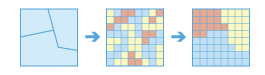
Válassza ki azt a területréteget, amely egy raszteres réteg összegzésére szolgál megadott határokon belül
The layer that defines the boundaries of the areas, or zones, that will be summarized.
The layer can be a raster or feature data. For rasters, the zones are defined by all locations in the input that have the same cell value. The areas do not have to be contiguous.
Válassza ki a mezőt a határok definiálásához
This is the attribute of the layer that will be used to define the boundaries of the areas.
For example, suppose the first input layer defines the management unit boundaries, with attributes that define the region, the district, and the parcel ID of each unit. You also have a raster layer defining a biodiversity index for each location. With the field you select, you can decide to calculate the average biodiversity at local, district, or regional levels.
Válassza ki az összegezni kívánt raszteres réteget
The raster cells in this layer will be summarized by the areas (zones) that they fall within.
Válassza ki a kiszámítandó statisztikát
Once you choose a layer to summarize, you can optionally calculate statistics of any numerical attribute of the points, lines, or areas within the input area layer.
The available statistics types when the selected field is integer are Average, Majority, Maximum, Median, Minimum, Minority, Range, Standard deviation, Sum, and Variety.
If the field is floating point, the options are Average, Maximum, Minimum, Range, Standard deviation, and Sum.
Hiányzó értékek figyelmen kívül hagyása a számításban
If you choose to ignore missing values, only the cells that have a value in the layer to be summarized will be used in determining the output value for that area. Otherwise, if there are missing values anywhere in an area, it is deemed that there is insufficient information to perform statistical calculations for all the cells in that zone, and that area will receive a null (NoData) value in the output.
Eredmény réteg neve
The name of the layer that will be created in My Content and added to the map. Az alapértelmezett név az eszköz nevétől és a bemenő réteg nevétől függ. Ha a réteg már létezik, akkor a program megkéri, hogy adjon meg egy másik nevet.
Az Eredmény mentési helye legördülő mezőben megadhatja a Saját tartalom mappájának nevét, ahová az eszköz menti az eredményt.