Sűrűség számítása
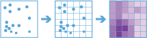
A Sűrűség számítása eszköz sűrűségtérképet hoz létre pontszerű vektoros elemekből egy bizonyos (a pontok attribútumai által képviselt) jelenség ismert mennyiségeit kiterjesztve a térképen. Az eredmény a legkevésbé sűrűtől a legsűrűbbig terjedő kategóriákba sorolt területeket tartalmazó réteg.
Pont bemenet esetén az egyes pontok feleljenek meg egy bizonyos esemény vagy incidens helyének, és az eredmény réteg megjeleníti az egységnyi területre eső incidensek számát. Az új helyen a nagyobb sűrűségérték azt jelenti, hogy több pont található az adott hely közelében. Sok esetben az eredmény réteg jövőbeni események kockázatát megjelenítő felszínként értelmezhető. Ha például a bemenő pontok villámcsapások helyének felelnek meg, akkor az eredmény réteg a jövőbeni villámcsapások kockázatát megjelenítő felszínként értelmezhető.
Az eszköz ezenkívül az alábbiakra is használható:
- Bűncselekmények sűrűségi térképének létrehozása, segítve ezzel a rendőrségnek az erőforrásokat azokra a területekre csoportosítani, ahol nagy arányú a bűnözés.
- A megyében található kórházak sűrűségének kiszámítása. Az eredmény réteg mutatja azokat a területeket, ahol magas és alacsony a kórházak elérhetősége, és ez az információ felhasználható annak eldöntésére, hogy hol épüljenek új kórházak.
- Olyan területek azonosítása, ahol magas az erdőtűz kockázata a korábbi helyszíne alapján.
- A nagyobb főútvonalaktól távol élő közösségek helyének meghatározása, annak megtervezéséhez, hogy hol épüljenek új utak.
Válassza ki azt a pontréteget, amelyből ki szeretné számítani a sűrűséget
A pontréteg, amelyből ki szeretné számítani a sűrűséget.
In addition to choosing a layer from your map, you can choose Browse Layers at the bottom of the drop-down list to browse to your contents for a big data file share dataset or feature layer.
Válasszon egy vagy több mezőt a sűrűség kiszámításához (opcionális)
Adja meg az egyes helyeken bekövetkezett balesetek számát meghatározó mezőt vagy mezőket. Városokat képviselő pontok esetén például a város népességének megfelelő mezőt használhat számláló mezőként, és az eredményül kapott népsűrűség réteg nagyobb népsűrűséget fog számlálni a nagyobb népességű városok közelében.
Az eszköz mindig kiszámítja a pontok darabszámának sűrűségét. Ha nincs kiválasztva mező, akkor az eszköz feltételezi, hogy az egyes helyek egyetlen értéket képviselnek.
Válassza ki a gyűjtő alakját
Azoknak a gyűjtőknek az alakja, amelyekbe a pontokat összesíti, és amelyeket a sűrűség kiszámításához használ.
Analysis using Square or Hexagon bins requires a projected coordinate system. You can set the Processing coordinate system in Analysis Environments. If your processing coordinate system is not set to a projected coordinate system, you will be prompted to set it when you Run Analysis .
Válassza ki az összevonási gyűjtőméretet
A létrehozott gyűjtők mérete. Négyszög alakú gyűjtő esetén a méret a négyszög magasságát jelöli. Hatszög alakú gyűjtő esetén a méret a hatszög (párhuzamos oldalaktól mért) magasságát jelöli.
Válassza ki az alkalmazandó sűrűségsúlyozást
A sűrűség számításakor alkalmazott súlyozás típusa. Kétféle lehetőség közül választhat:
- Egységes – területenként számít nagyságrendet.
- Kernel – egy kernelfüggvény segítségével illeszt kisimított kúpfelületet minden egyes pontra.
Válassza ki a szomszédság méretét
A sűrűség számításához használt terület mérete. A szomszédság méretének nagyobbnak kell lennie a gyűjtő méreténél.
Válassza ki a kimeneti mértékegységeket a sűrűséghez
A sűrűségértékek kívánt kimeneti mértékegységei. Alapértelmezés szerint négyzetkilométerre vagy négyzetmérföldre van állítva a profilban meghatározott alapértelmezett mértékegységtől függően. Ha a sűrűségértékek nagyon kicsik, növelheti a területi mértékegységek nagyságrendjét (például négyzetméterről négyzetkilométerre), hogy nagyobb értékeket kapjon. Az értékek csak az eredmények méretarányát módosítják.
Sűrűség számítása időbeli lépések használatával (opcionális)
If time is enabled on the input point layer and it is of type instant, you can analyze using time stepping. There are three parameters you can set when you use time:
- Time step interval
- How often to repeat the time step
- Time to align the time steps to
For example, if you have data that represents a year in time and you want to analyze it using weekly steps, set Time step interval to 1 week.
For example, if you have data that represents a year in time and you want to analyze it using the first week of the month, set Time step interval to 1 week, How often to repeat the time step to 1 month, and Time to align the time steps to to January 1, at 12:00 am.
Időbeli lépés intervalluma
The interval of time used for generating time steps. Time step interval can be used alone or with the How often to repeat the time step or Time to align the time steps to parameter.
For example, if you want to create time steps that take place every Monday from 9:00 a.m. until 10:00 a.m., set Time step interval to 1 hour, How often to repeat the time step to 1 week, and Time to align the time steps to to 9:00:00 a.m. on a Monday.
Az időbeli lépés ismétlésének gyakorisága
The step used for calculating a time step. How often to repeat the time step can be used alone, with Time step interval, with Reference Time, or with both Time step interval and Time to align the time steps to.
For example, if you want to create time steps that take place every Monday from 9:00 a.m. until 10:00 a.m., set Time step interval to 1 hour, How often to repeat the time step to 1 week, and Time to align the time steps to to 9:00:00 a.m. on a Monday.
Az időbeli lépések igazításához használt idő
The date and time used to align time slicing. Time stepping will start at and continue backward from this time. If no reference time is selected, time stepping will align to January 1st, 1970.
For example, if you want to create time steps that take place every Monday from 9:00 a.m. until 10:00 a.m., set Time step interval to 1 hour, How often to repeat the time step to 1 week, and Time to align the time steps to to 9:00:00 a.m. on a Monday.
SpatialReference (WKID)
This is a temporary parameter for prerelease to set the processing spatial reference. Many big data tools require that a projected coordinate system is used as the spatial reference for processing. By default, the tool will use the input coordinate system but will fail if it's a geographic coordinate system. To set a projected coordinate system, enter the WKID. For example, Web Mercator would be entered as 3857.
Adattár választása
GeoAnalytics results are stored to an ArcGIS Data Store and exposed as a feature layer in Portal for ArcGIS. In most cases, results should be stored to the spatiotemporal data store and this is the default. In some cases, saving results to the relational data store is a good option. The following are reasons why you may want to store results to the relational data store:
- You can use results in portal-to-portal collaboration.
- You can enable sync capabilities with your results.
You should not use the relational data store if you expect your GeoAnalytics results to increase and need to take advantage of the spatiotemporal big data store's capabilities to handle large amounts of data.
Eredmény réteg neve
The name of the layer that will be created in My Content and added to the map. Az alapértelmezett név az eszköz nevétől és a bemenő réteg nevétől függ. If the layer already exists, the tool will fail.
Az Eredmény mentési helye legördülő mezőben megadhatja a Saját tartalom mappájának nevét, ahová az eszköz menti az eredményt.