Clip Layer
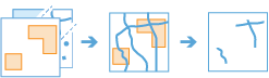
The Clip Layer tool extracts input point, line, or area features that overlay the clip areas. The output is a subset of your input data based on the areas of interest. The following are examples:
- Which major rivers are within the state of Nebraska?
- Which houses are within a coastal flood zone?
- Which hurricanes made landfall in 2011?
Choose features to clip
The point, line, or area layer that will be clipped. You'll create a subset of these features..
In addition to choosing a layer from your map, you can choose Browse Layers at the bottom of the drop-down list to browse to your contents for a big data file share dataset or feature layer.
Clip all features or define a subset (optional)
Identify the input features you want to clip.
Choose area to clip to
The area layer to which you'll clip input layer features. These areas determine subset boundaries.
In addition to choosing a layer from your map, you can choose Browse Layers at the bottom of the drop-down list to browse to your contents for a big data file share dataset or feature layer.
Result layer name
The name of the layer that will be created in My Content and added to the map. The default name is based on the tool name and the input layer name. If the layer already exists, the tool will fail.
Using the Save result in drop-down box, you can specify the name of a folder in My Content where the result will be saved.